Unveiling the Advantages of 3D Property Scanning
Blogs
Benefits of 3D Scanning for Properties: Cost, Precision, and Time Efficiency
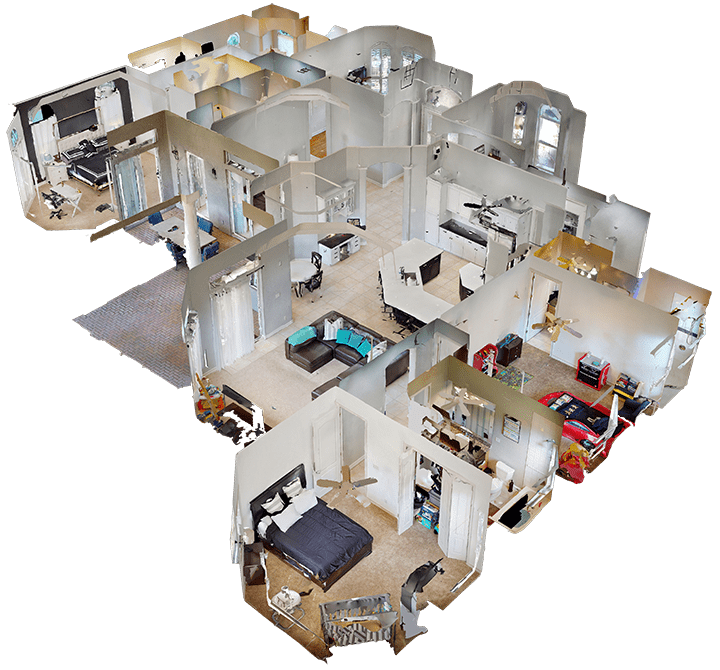
The worlds of construction and real estate are constantly evolving, demanding greater precision and efficiency than ever before. While traditional surveying methods have served the industry for years, they often come with limitations in accuracy and speed. Today, 3D property scanning is transforming how we design, build, and manage properties. This advanced technology provides a comprehensive and highly accurate digital representation of any physical space. It moves beyond the constraints of manual measurements, offering a powerful tool that delivers detailed insights, streamlines workflows, and sets a new standard for projects across the board.
Exceptional Accuracy
Significant Time Savings
Cost Efficiency Throughout the Project Lifecycle
Detailed As-Built Documentation for Every Stage
Streamlined Project Planning and Coordination
Enhanced Visualizations for Clients and Stakeholders
Improved Safety by Minimizing On-Site Risks
Effective Space Utilization Analysis
Reduced Risk of Human Error in Surveying
Exceptional Accuracy for Real Estate and Construction Projects
One of the most significant advantages of LiDAR scanning is its unparalleled level of accuracy. Unlike traditional surveying methods that rely on manual measurements with tapes and theodolites, 3D scanners capture millions of data points in minutes. This process creates a dense and detailed point cloud, representing the exact dimensions and geometry of a space with millimeter-level precision. This high fidelity ensures that every corner, curve, and surface is documented correctly.
How does 3D property scanning improve accuracy compared to traditional surveying methods?
Traditional methods are susceptible to human error, such as misreading a measurement, transcription mistakes, or overlooking complex architectural details. Property scanning automates the data collection process, removing these variables and providing objective, verifiable information. The result is a set of accurate measurements that construction professionals can trust completely.

Significant Time Savings in Property Surveys
Time is a critical resource in any project, and 3D property scanning offers substantial time savings compared to conventional approaches. A traditional survey process can take hours, or even days, for a moderately sized building. In contrast, a LiDAR scanner can capture a comprehensive dataset of an entire site in a fraction of the time, dramatically accelerating the initial data collection phase.
Can you explain how 3D scanning saves time during property surveys?
The speed comes from the technology’s ability to gather millions of measurements simultaneously. Instead of a surveyor taking individual measurements one by one, the scanner rotates and captures everything within its line of sight in a single operation. This comprehensive capture also eliminates the need for return site visits to gather missed or forgotten details, as the complete point cloud contains all the information needed.
This efficiency translates into a faster overall project timeline.
Key time-saving benefits include:
- Rapid on-site data capture that reduces hours or days of manual labor to mere minutes.
- Fewer personnel required on-site to conduct the survey.
- Elimination of return site visits for additional measurements or clarifications.
- Quicker processing of data into usable 3D models for design and planning teams.
Cost Efficiency Throughout the Project Lifecycle
While 3D property scanning involves an initial investment, it delivers significant cost savings across the entire project lifecycle. The high accuracy of the data captured at the outset helps prevent errors that could lead to expensive rework during the construction phase. By identifying potential clashes and discrepancies in the digital model before any physical work begins, teams can address issues virtually when it is cheapest to do so.
Why is LiDAR scanning considered cost-effective for property development projects?
The primary reason is risk mitigation. Misalignments, structural conflicts, and design flaws caught late in the process often require demolition and rebuilding, leading to huge budget overruns and project delays. Property scanning provides a robust quality control mechanism from day one, ensuring that the design aligns perfectly with existing conditions and that construction proceeds as planned.
This proactive approach to error detection minimizes material waste, reduces labor hours spent on corrections, and keeps the project on its financial track. The cost savings extend beyond the construction phase, as the accurate digital record helps streamline facility management and future renovations, making the technology a wise investment for long-term asset owners. For 3D property Scanning Dubai services, this efficiency is crucial in a fast-paced market
This digital record becomes an invaluable asset for building owners and managers, providing a reliable reference for any future renovations, repairs, or operational planning. It offers a transparent and verifiable account of the construction process.
Detailed As-Built Documentation for Every Stage
As-built documentation is the official record of a project as it was actually constructed, including any changes made during the process. Creating this documentation accurately is vital for regulatory compliance, future maintenance, and facility management. 3D property scanning revolutionizes this process by providing an exact digital snapshot of the property at various project stages.
How does 3D scanning help in creating accurate as-built documentation?
By capturing the precise location of structural elements, MEP (mechanical, electrical, plumbing) systems, and finishes, the scan data creates a perfect digital twin of the real-world conditions. This information is far more reliable than traditional methods, which often involve manually marking up 2D drawings and are prone to inaccuracies and omissions.
The accurate data from the scan can be used to update BIM models or CAD drawings, ensuring that the final as-built records are a true representation of the completed work.
Enhanced Visualizations for Clients and Stakeholders
Communicating complex project designs to clients and non-technical project stakeholders can be challenging with traditional 2D drawings. 3D property scanning bridges this gap by transforming complex scan data into enhanced visualizations that are easy to understand. These can include realistic 3D models, photorealistic renderings, and interactive virtual tours.
This technology creates an immersive experience, allowing stakeholders to “walk through” a property before it is built or renovated. They can explore the space, understand the layout, and get a true feel for the final product.

Effective Space Utilization Analysis
Optimizing the use of space is crucial for the profitability and functionality of commercial and residential properties. 3D property scanning provides the accurate measurements and detailed floor plans needed for effective space utilization analysis. Business owners, facility managers, and real estate professionals can use this data to make informed decisions about layouts, redesigns, and leasing.
With a precise 3D model, you can analyze every square foot of a property. This allows for the strategic planning of retail layouts to improve customer flow, the redesign of office spaces to enhance collaboration, or the verification of leasable area for commercial contracts. The model can be used to test different furniture arrangements or operational workflows virtually before any physical changes are made.
The detailed data captured by a 3D scan provides insights that go beyond simple floor plans. It offers a clear understanding of vertical space, structural constraints, and MEP system locations, all of which are critical for comprehensive space planning.
Feature Analyzed | Benefit of 3D Property Scanning |
|---|---|
Total Square Footage | Provides exact, verifiable area measurements for leasing and sales. |
Room Layout & Flow | Allows for virtual redesign and optimization of customer or employee traffic. |
Accessibility Compliance | Verifies adherence to standards like door widths, ramp slopes, and clear floor space. |
Vertical Space | Captures ceiling heights and overhead obstructions for storage or equipment planning. |
Streamlined Project Planning and Coordination
Effective project planning and coordination are essential for a successful construction outcome. 3D property scanning provides a shared, data-rich environment that enhances collaboration between all project teams, including architects, engineers, and contractors. With everyone working from the same accurate 3D model, misunderstandings and miscommunications are significantly reduced.
In what ways does 3D property scanning enhance project planning and coordination?
One of the most powerful applications is clash detection. Before construction begins, the 3D model allows project teams to overlay different building systems—such as HVAC ducts, plumbing pipes, and electrical conduits—with the structural frame. This virtual analysis automatically flags any areas where these systems conflict or interfere with each other.
Resolving these clashes in the digital phase is simple and costs nothing compared to discovering them on-site, where they would cause delays and require costly modifications. This proactive coordination ensures a smoother construction process, as everyone on the team has a clear and unified understanding of the project design and its implementation. This leads to better decision-making and a more efficient workflow from start to finish.

Improved Safety by Minimizing On-Site Risks
Safety is a top priority on all construction sites. 3D property scanning helps create a safer working environment by reducing the need for personnel to access hazardous or hard-to-reach areas. Since LiDAR scanning is a non-contact technology, the scanner can be placed in a secure location while capturing detailed data of its surroundings, including high ceilings, unstable structures, or busy operational areas.
This remote data collection capability is invaluable for assessing dangerous site conditions without putting workers at risk. For example, instead of sending a surveyor to manually measure a fragile historic building or a busy highway overpass, a scanner can do the job from a safe distance. This minimizes exposure to potential falls, structural collapses, or traffic-related accidents.
Furthermore, the comprehensive 3D models created from the scans can be used for safety planning. Project managers can identify potential hazards, plan safe access routes, and coordinate work activities more effectively. By providing a clear and accurate understanding of the entire site, 3D property scanning helps mitigate risks before workers even step foot in a potentially dangerous area.
Frequently Asked Questions
How does 3D property scanning improve the accuracy of property measurements?
How to Prepare a Site for 3D Scanning?
Quick Links
Contact:
+971 58 599 6983
info@3deex.ae